Whitehaven Location
Maps and Directions for Whitehaven
If you want to visit I hope the following will give help on how to get to
Whitehaven.
Whitehaven is located on the West Coast of Cumbria in the North of England
in the United Kingdom. From a Maritime point of view this means it is on the edge of the
Solway Firth with an easy sail across to the Isle of Man or Dumfries and Galloway on the
South West coast of Scotland. For walkers and cyclists it is on the edge of the Lake
District National park, start of the C2C cycle route and an alternative starting point for
Wainwright's coast to coast walk which officially starts at nearby St. Bees.
The co-ordinates are 54 degrees 33 min. North 3 degrees 35 min. West.
The best way to get to Whitehaven is to be born here - but failing that there are road
and rail links that will get you here.
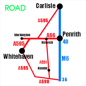
By Road:
- Of course there are several routes available but the easiest and probably quickest is
along the M6 motorway - turning off at junction 40 at Penrith - heading West along the A66
and then before you get to Workington there is a roundabout where you head South along the
A595 which passes through Whitehaven. This route passes Lake Bassenthwaite. [time 1hr from
Penrith]
- An alternative route from the South which is even more scenic is to Turn off the M6 at
Junction 36 and take the A591 through Kendal, Windermere and Ambleside to Keswick then
following the A66 west as above. (Note: this route can be slow when the roads are packed
with tourists.) This route passes lakes Windermere, Grasmere, Rydal and Thirlmere. Also
note that on a map is an attractive looking shortcut from Ambleside to Eskdale. However,
this passes over Hardknott Pass and is only for small, reliable cars driven by someone
with a spirit of adventure in good weather. It is not for stretched
limo's, caravans or heavy goods vehicles driven in bad weather by drivers of a nervous
disposition - although such attempts have provided much entertainment for the locals in
the past.
- Also turning off at Junction 36 you can follow the A595 along the coast to Whitehaven.
This route passes Morecambe Bay and the Duddon Estuary.
- From the North if you don't want to use the M6 you can take the A595 from Carlisle
reaching the A66 just west of Cockermouth and continuing west as above or branch off onto
the A596 and follow the coast south past Maryport and Workington.
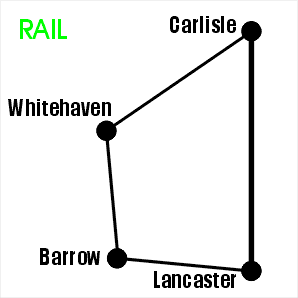
By Rail:
- It is usually best to go to Carlisle and connect there for a train heading along the
coast to Whitehaven [time 1hr 10mins].
- The other alternative is to change at Lancaster for the train to Barrow and follow the
coast North but these trains are less frequent so connections could cause delays. [time
2-3hrs]
To find Whitehaven on Google Maps
For information on Rail Time
Table
For local Bus Time table
For more information on C2C
Please check journey details with another source before setting off.
Return to home page